Introduction
On November 8, 2013, Typhoon Haiyan, also known as Super Typhoon Yolanda, the strongest tropical cyclone ever to make landfall based on wind velocities, cut a devastating swath across the central Philippines. The storm strength was equivalent to a Category 5 hurricane (the highest level of intensity) with sustained wind speeds at landfall of 195 mph, the highest ever recorded, and gusts up to 235 mph. Nearly 13 million people were affected, 13% of the nation’s entire population. There were at least 6,300 fatalities and 28,700 injuries. Because of the lightweight construction materials and the extreme wind velocities, over 281,000 houses were reported as destroyed, with 1.9 million people displaced.
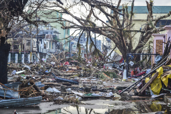
This super typhoon had been closely tracked for six days across the western Pacific as its strength increased before making landfall. As the storm intensified, evacuation warnings were given, including the highest level of warning, indicating very high winds. Although wind speeds were extreme, the major cause of damage and loss of life appears to have been storm surge. Water reached 17 feet above sea level at the center of the low-lying and most damaged area, Tacloban City, where the terminal building at the airport was destroyed when the surge reached the second story. The entire first floor of the Tacloban City Convention Center, which was serving as an evacuation shelter, was submerged by storm surge. Many people in the building were surprised by the fast rising waters and subsequently drowned or were injured.
The most immediate threats to survivors of this typhoon, in order of urgency, were lack of safe drinking water, no shelter, untreated injuries and illnesses, insufficient food, lack of sanitation and personal hygiene items, and shortage of household supplies like fuel. Even with advance warnings, when a storm of this magnitude hits a nation with a densely populated coastal area like The Philippines, the damage, death and injury toll is going be high. In all likelihood, there will be equally and more damaging typhoons in the future. Are there things we can do to prepare for and reduce damage and loss of life from recurring events like this?
The Formation of Tropical Cyclones
Tropical cyclones in the North Atlantic, Caribbean, and eastern Pacific are known as hurricanes. In the Indian Ocean, the same type of severe storm is referred to as a monsoon, whereas in the western Pacific, China, Japan or the Philippines, they are called typhoons. But these are all tropical cyclones, which are very large, warm, humid, rotating air masses. In order to be designated as a hurricane or typhoon, a tropical cyclone must generate wind speeds of at least 74 mph (119 km/h). Cyclones that don’t develop these high winds are known as tropical storms and tropical depressions, but can change their status without warning as they become fully developed. Some of the most damaging tropical cyclones have occurred in Southeast Asia where population densities in exposed, low-lying coastal areas are often high, and many of the buildings are of lightweight construction.
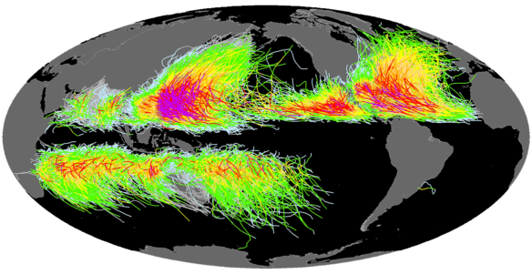
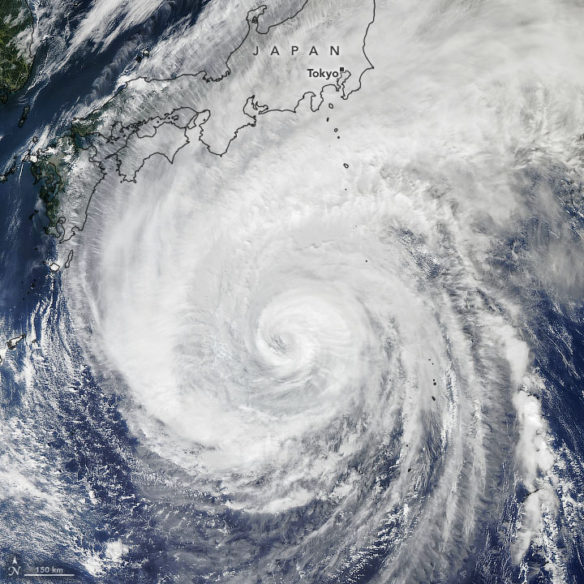
Despite centuries of disasters and decades of study, we still don’t fully understand exactly how a tropical cyclone forms. Hurricanes, such as those that approach the Atlantic coast of the U.S. or pass through the Caribbean Sea, typically have their origins between about 5 and 25 degrees north latitude (southern hemisphere tropical cyclones have their origins between 5 and 25 degrees south latitude). In these tropical latitudes, the air is warm and air-pressure gradients are weak. Many of these storms are born as hot air rises off the west coast of Africa and begins to move westward with the trade winds. Warm, moist air above the ocean flows into this air mass from below and is expelled at the top. As the warm air rises, moisture condenses, releasing both heat and rain while wind velocities increase.
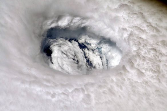
In order for this column of air to rise high into the atmosphere, and for the characteristic rotating winds to form, the variation in wind velocities at different elevations must be small. This growing disturbance feeds on the warm tropical ocean and the hot tropical air, which slowly turns this swirling mass into a heat engine, spinning counterclockwise in the northern hemisphere (and clockwise in the southern hemisphere). As the warm air expands and cools aloft, it releases its heat. As this process intensifies, the storm can strengthen, although strong winds near the top of this column can shear off the top, causing dissipation or collapse of the potential storm. Where one of these rotating spirals continues to develop and expand, it can evolve into a tropical storm and eventually a hurricane.
In the northern hemisphere these tropical cyclones rotate counterclockwise but overall they migrate or track in a clockwise direction, similar to the ocean currents in the northern hemisphere. In the southern hemisphere, the patterns are exactly the opposite, with clockwise rotation but counterclockwise migration. Those tropical storms that form in the north Atlantic off West Africa, continue to move westward, increasing their velocity and energy, and may develop into full-fledged hurricanes by the time they reach the Caribbean or the South Atlantic coast of the U.S. Typhoons that form in the western Pacific will follow similar paths towards Asia.
In any given year, 90 to 100 tropical storms may form somewhere around the planet, but only five or six in the Atlantic or Gulf of Mexico will develop into fully-fledged hurricanes and be given formal names. As summer transitions into autumn, residents of the Gulf and Atlantic coast states often have unwelcome and poorly behaved guests with names like Andrew, Camille, Ike, or Katrina, who may tear their roofs off or, even worse, destroy their entire house. Hurricanes began receiving proper names in the 1950s after an older system based on latitude and longitude was no longer seen as user-friendly. So in the U.S., the National Hurricane Center releases a group of names for each Atlantic hurricane season. This is a list of short, distinctive names selected to be easy to pronounce and culturally sensitive. After a particularly disastrous hurricane, Andrew in 1992 or Wilma in 2005, for example, just like the number on a star professional athlete’s jersey, a name can be retired so as not to be confused with subsequent events given the same name in later years.
The Impacts and Damage from Hurricanes
While relatively harmless at sea, other than if you happened to be in a small boat far from shore, as these tropical cyclones approach land their true impacts and potential for devastation is quickly realized. They routinely cause billions of dollars in damage, can take thousands of lives, and have major impacts by modifying the shoreline through beach and dune erosion and deposition.
While the official Atlantic hurricane season extends from June 1 to November 30 each year, the peak of the season usually occurs in August and September when ocean water temperatures are the highest. Although we tend to think of the Gulf and South Atlantic coasts of the United States as the areas most exposed to hurricane damage in the U.S., the paths of these tropical cyclones on occasion can reach as far north as New England, especially where areas like Long Island, Rhode Island and part of Massachusetts extend out into the Atlantic.
About 61 million people live today in coastal counties that are vulnerable to hurricanes along the U.S. Gulf and South Atlantic coasts, and like most coastal regions, these populations continue to increase. From 1900 to 2015, there were 631 hurricanes that affected these counties as well as the Caribbean region, or 5.4/yr. on average; 245 of these, or about two each year, have been classed as major hurricanes based on damage and death tolls. During this same 115-year period, there have been at least 92,630 fatalities (this is an underestimate because death tolls for some older hurricanes are not known for certain), or an average of over 800 fatalities per year.
Hurricanes have been responsible for more loss of life in the U.S. than any other natural hazard. Overall damage due to hurricanes from 1900-2015 totaled nearly $490 billion, or an average of $4.2 billion annually. If hurricane costs are adjusted to 2005 for changing societal conditions, this number more than doubles to about $10 billion per year. These losses are increasing in large part because more people are moving to hurricane-prone coastal counties, but also because the investments in homes and other developments, and their values, are increasing. Six of the ten most destructive hurricanes between 1900 and 2006 occurred in 2004 and 2005, and then we can add Superstorm Sandy on top of those.
In 2010, the total population in coastal counties along the Gulf and Atlantic coasts of the U.S., extending from Texas to New York, which is exposed to hurricanes, was 19% of the total U.S. population. These coastal populations are projected to increase about 10% by 2020, or by an additional 6.1 million people. The percentage increase in people 65 and older has been growing far faster (about 2-4 times faster) than the total population. Without some action to address the increasing concentrations of people and development in these coastal areas where hurricanes have historically made landfall, damage will increase as more people choose to relocate to these areas.
Types of Hurricane Damage
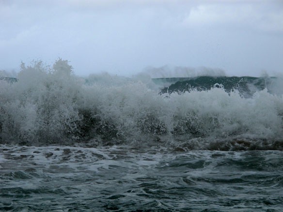
Hurricane damage can be inflicted by the high velocity winds, by the impact of large storm waves and also the elevated sea levels and flooding, whether from storm surge (salt water) or from high rainfall (fresh water), that accompany these tropical or sub-tropical cyclones. Structures engineered to withstand hurricane force winds may well not have been designed to deal with flooding or submergence. In fact, most homes are not designed to withstand submergence.
Damage from Wind
Wind velocities during hurricanes start at 74 mph (119 km/hr.), or the lower threshold for classification as a hurricane) and increase from there. Velocities commonly reach 150 mph, and the maximum sustained wind speed ever recorded was during a Super Typhoon Yolanda in the Philippines in 2013 when gusts up to 235 mph were measured. The pressure exerted by the wind is proportional to the velocity squared, so that a doubling of the wind speed produces four times as much force. As a result, the destructive power of high-velocity winds can literally blow structures over or apart. Wind speeds of 150 mph exert about 116 lbs./ft2) pressure on a wall or roof of a structure. Wind generally will produce much more damage than flooding, although once a roof is ripped off or windows are blown out, rain can enter a building and exacerbate the damage. There are many proven construction materials and methods that can help reduce wind damage: steeper vs. flatter roofs and eliminating overhanging eaves; roofing materials, with concrete, metal or tile roofs being more resistant to wind than shingles; laminated and tempered glass windows, and strong shutters or plywood covers over windows. Nonetheless, during severe hurricanes with very high velocity winds, all bets are off and there are countless examples when entire oceanfront neighborhoods have been completely destroyed.
Storm Surge
The flooding of low-lying areas during hurricanes is usually caused by the interaction of several processes including storm surge (also often referred to as storm or hurricane “tides”, although they are unrelated to the tide) and large breaking waves. High wind velocities and low atmospheric pressures can allow the sea surface to rise near shore, which in extreme cases may be as high as 25 feet above normal predicted sea level.
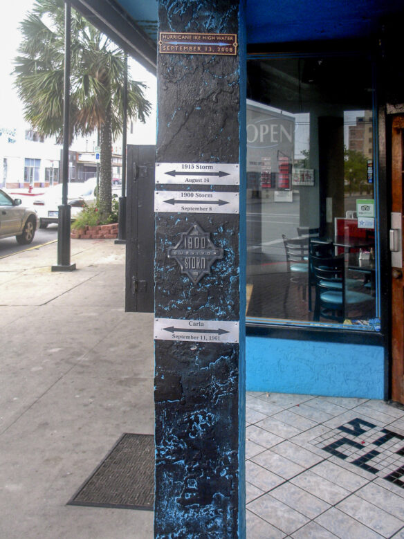
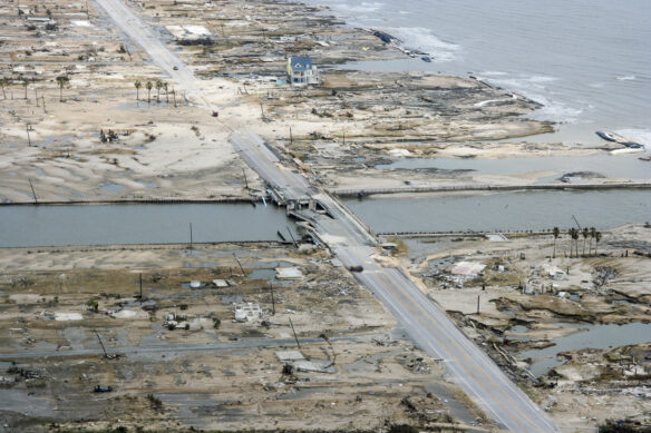
In the great Galveston Island hurricane of 1900 (known also as Isaac’s Storm, named after the local weatherman who tried to warn the city), the storm surge reached nearly 15 feet above normal tides and washed completely over the island, which had an average elevation of about 9 feet above sea level. The city was completely unprepared and was nearly totally destroyed as large wooden houses and other structures literally floated away. The death toll was between 6,000 and 12,000 in a city of 36,000, making it the deadliest natural disaster in U.S. history. Hurricane damages adjusted to 2015 dollars have been calculated at $1.55 billion. In rebuilding Galveston, sand and mud were pumped out of the bay to raise the elevation of part of the island 17 feet above its former elevation, and a large seawall, 21 feet high was built to provide protection for 10 miles of the eastern, more developed end of 30-mile-long Galveston Island. All protection usually ends somewhere, however, and the Galveston seawall does not protect the western end of the island or the inland side of the island from storm surge.
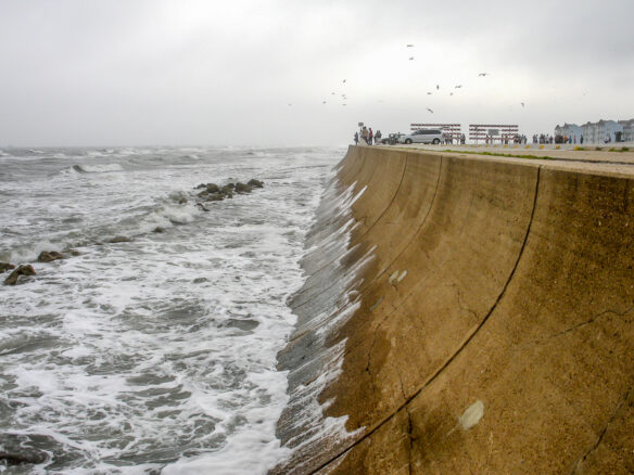
One hundred and eight years later, Hurricane Ike passed directly over Galveston Island. The storm surge reached up to 20 feet above normal tide, 5.2 feet above the 1900 hurricane level, and overtopped the seawall built after the devastating hurricane of 1900. Ike left behind $29.5 billion in losses, making it the 3rd costliest Atlantic hurricane at the time (Figure 3.5 and 3.6). The backside of the island, that seemed to be protected, but was at a significantly lower elevation than the area immediately behind the seawall, suffered major damage from storm surge.
This points out one of the engineering challenges involved in trying to protect infrastructure, communities, or cities from severe or infrequent natural hazards, whether hurricanes, floods or earthquakes. No entity or agency can afford to provide complete protection from all potential natural hazards. So some design event, often the 100-year flood, for example, is agreed upon, calculations are made, and the protection is engineered or designed accordingly. Nonetheless, depending upon the number of years of observations or measurements (e.g. the length of the flood record), or changing environmental conditions (rising sea level, for example), the design event selected at one point in time, may not be an accurate projection of the risks from the particular event in the future.
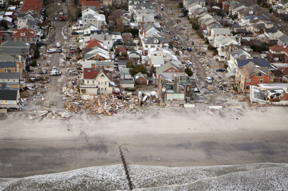
During Superstorm/Hurricane Sandy in 2012, the strength and angle of approach combined to produce a record storm surge in New York City. The water level recorded at Battery Park, at the southern tip of Manhattan, topped 13.9 feet, exceeding the 10.2 feet record set by Hurricane Donna 52 years earlier. The East River (which is not really a river at all, but a tidal channel) overflowed its banks, flooding large sections of lower Manhattan. Seven subway tunnels under the East River were flooded causing the greatest damage in the 108-year history of the Metropolitan Transportation Authority. The storm surge flooded the Ground Zero construction site, and over 10 billion gallons of raw and partially treated sewage were released by the storm into the surrounding waters. Considerable damage to homes and other buildings, roadways, boardwalks and mass transit facilities in low-lying coastal areas of both New York and New Jersey was caused by the storm surge, combined with large waves. Seventy-two people died as a result of Hurricane Sandy, and total damages reached about $50 billion, making it the second most costly storm in U.S. history, after Katrina.
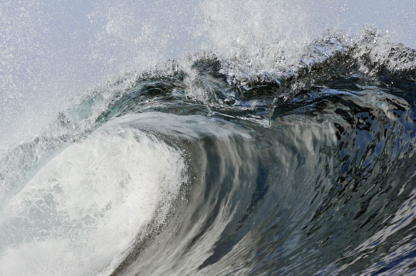
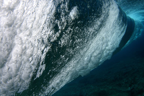
Damage from Waves
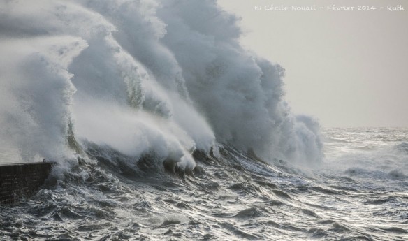
Hurricane-force winds blowing over large expanses of sea surface for several days can generate very large waves. During Hurricane Sandy, a buoy off New York measured a wave 32.5 feet in height, a record for that location, surpassing by over six feet the largest wave generated by Hurricane Irene that passed through the same area in 2011. Large waves combined with a storm surge will break closer to shore and intensify the damage that either might cause alone. Large hurricane driven waves will scour sand, eroding protective dunes and beaches, leaving only the structures themselves behind to withstand wave impact. Waves can damage or destroy homes, roads, bridges, and piers. Hurricanes can break through barrier islands, cutting new tidal channels and leaving some island areas completely cut off from the mainland. Building codes in some hurricane prone areas require elevation on pilings or posts, but depending upon the depth of embedment into the sand and the amount of beach scour, as well as storm surge and wind velocities, even this has not been enough to protect many structures. In Sandy, entire beachfront communities built on the sand in New York and New Jersey were flooded, tipped over, washed inland, or completely demolished by waves and storm surge.
Rainfall and Flooding
Many tend to think of hurricanes, cyclones, or typhoons as primarily coastal hazards, but the intense rainfall that occurs as these disturbances move inland can be even more damaging than coastal impacts. The size of the storm, the speed at which it advances, and the inland topography and vegetation or land cover exert the major influences on how much rain falls, over how large an area, how fast it runs off and then downstream impacts. Where cyclones are large, topography is steep, and these fronts move slowly, rainfall can be very heavy. Where mountains or topographic barriers exist near the coast, precipitation during a large cyclone can be extreme and many world rainfall records result from these conditions. The island of Reunion in the Indian Ocean is one good example where a record 45 inches of rain has fallen in just 12 hours, 72 inches of rain has fallen in a single day, and 97 inches or just over eight feet of precipitation took place in just two days- all global records.
Tropical Storm Allison passed over Houston, Texas, in 2001, and dropped 37 inches of rain in 36 hours, which was ¾ of the average annual rainfall for the city. Flooding in the fourth largest city in the nation damaged more than 45,000 homes and businesses. The storm left 41 dead, and over $12 billion in damage (2015 dollars) and became the costliest tropical storm in US history
Hurricane Katrina
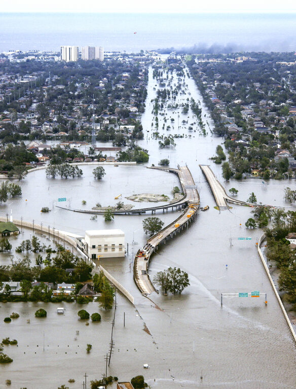
Hurricane Katrina, which hammered the Gulf Coast in late August 2005, was one of the deadliest hurricanes to ever strike a U.S. coast, causing the death of 1,833 people. Katrina also produced the greatest amount of damage, $108 billion, in losses of any recorded storm. After passing over Florida, the storm wreaked havoc on Biloxi and Gulfport, Mississippi, then continued west across southeastern Louisiana with devastating storm surges ranging from 10 to 28 feet above sea level. The combined effects of large waves and the storm surge led to the collapse of the levees protecting New Orleans. Eighty percent of the city was ultimately flooded, displacing over a million people.
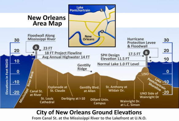
One of the challenges of protecting New Orleans is that over half of the entire city lies below sea level, in fact, on average its about six feet below sea level. To make matters worse, because of the history of draining wetlands and ground water extraction, as well as the overall subsidence of the Mississippi Delta from thousands of feet of accumulated sediment, the city is sinking and has been for decades. The closest tide gage to New Orleans at Grand Isle, has recorded a rise in sea level relative to the land of 9.03 mm/yr., or three feet/100 years. This is about five times higher than the average global rise in sea level. To call this a serious problem would be an understatement, and it presents major challenges for this colorful and historic city, challenges that will only be amplified in the future as the level of the oceans continue to rise and the level of the land continues to sink.
New Orleans actually sits in a depressed bowl between the Mississippi River levees on one side and the levees around Lake Pontchartrain on the other. Because of its low elevation relative to sea level, and also the reduction of much of the original natural protection that was provided by wetlands and barrier islands from storm surges, New Orleans is extremely vulnerable to hurricanes. The wetlands and barrier islands have been shrinking and eroding as a result of the channelization of the Mississippi River for shipping such that floods don’t replenish the sediments as they did under natural conditions. Because of its location in this bowl, once flooded it takes a very long time to remove the floodwaters and begin to recover. The impact of Hurricane Katrina on New Orleans was amplified by a combination of poor pre- and post-hurricane responses, and rescue and recovery efforts at the local, state and federal levels. A select bi-partisan congressional committee charged with investigating the responses concluded that there was plenty of blame to go around and that there were serious failures at all government levels. An aging and poorly maintained federal system of levees, failure of residents to respond to evacuation warnings, slow and uncoordinated responses at every level of government, all contributed to the disaster.
In response, levees were rebuilt higher and with a deeper support system, Congress passed legislation to reorganize FEMA to make it more responsive, and New Orleans improved their emergency response and communication system. Yet parts of New Orleans have never recovered. If we are to reduce losses from future events, we must learn from every natural disaster and ensure the same mistakes, the same uncoordinated agency responses and communication failures are remedied and don’t recur.
Future Hurricane Vulnerability of the Atlantic and Gulf Coasts of the United States
As more people continue to migrate to the Sunbelt states and home prices and property values keep rising, the exposure and liability from future hurricanes has increased. The insured value of property along the Atlantic and Gulf coasts jumped from $7.2 trillion in 2004 to $10.6 trillion in 2012. Miami has some of the most expensive real estate in the nation, yet it is one of the five coastal cities most vulnerable to future hurricanes. And oceanfront construction is continuing at a record pace. Perhaps most ominous for Florida, projections are that populations in Florida counties at or near the coast are expected to rise by 16 percent between 2010 to 2020, matched or surpassed only by South Carolina (17 percent), Virginia (18 percent) and Texas (19 percent), all hurricane vulnerable areas. A leading insurance spokesman reported at a National Hurricane Conference in 2015 that this projected population growth means not only more homes, but also more businesses, and more public buildings – schools and hospitals – and infrastructure in “harm’s way” and that “too many people are in denial about the risk.”
A key issue facing many East Coast cities, in particular, is that sea-level rise due to global warming and land subsidence is already making it more likely that damaging storm surge flooding will take place, even during weaker hurricanes. The following list of the top five most vulnerable U.S. cities to a hurricane landfall, and why, comes from a presentation from an insurer’s perspective (and insurance companies, for financial liability reasons, are usually on the front line of risk projection). The list takes into consideration storm frequency and historic tracks, and city vulnerability, including the population living at or below storm surge elevations. This is certainly not a complete list and almost every city along the Gulf and East Coasts are potential targets for hurricanes. It does, however, include some of the potential hurricane hot spots that keep weather forecasters worrying.
- Tampa-St. Petersburg, Florida
The Tampa-St. Petersburg area, on the west coast of Florida, is extremely vulnerable to storm surge flooding, and has been fortunate to escape a direct hit from a strong hurricane for many years. Climate Central calculates the 100-year flood height in this area is 6.5 feet above the high tide line and that about 125,000 people are currently living below this flood level. In St. Petersburg alone, there are more than 45,000 homes that lie below 6 feet in elevation, and would likely be vulnerable to a storm surge of that magnitude or greater.
- Miami, Florida
Miami has experienced its share of historic hurricanes, but residents haven’t experienced a major storm since Andrew in 1992, which flattened southern portions of Miami, including the communities of Homestead and Florida City. The combination of sea-level rise, population growth, and new construction in coastal areas is increasing the threat of storm surge-related coastal flooding. About 56,000 people in Miami Beach and 23,000 people in Miami live below Climate Central’s Surging Seas 100-year flood height of three feet above high tide.
- New Orleans, Louisiana
About half of New Orleans lies below sea level, and 340,000 people live below the 100-year flood level. Although Hurricane Katrina was a disaster for New Orleans because of levee and dike failure and because so much of the city is below sea level, a hurricane should pass within 50 miles of the city every 7-11 years on average. The ongoing loss of wetlands in southeastern Louisiana is continuing to remove natural protection for the city from future storm surges. .
- Norfolk/Virginia Beach, Virginia
While Norfolk and nearby Virginia Beach are often missed by the most intense storms, they are vulnerable to hurricanes that move up the Eastern Seaboard and were impacted in 2011 by Hurricane Irene. The U.S. Navy’s largest base is located on low-lying land in Norfolk. Due to subsidence of the land and increased rates of sea-level rise, the shoreline of Virginia’s Chesapeake area is particularly vulnerable to flooding from future storm surges with 40,000 people living below the 100-year storm level.
- Houston/Galveston, Texas
Galveston was the site of America’s worst recorded hurricane disaster, when Isaac’s storm struck in 1900, sending a storm surge completely across the island, killing between 6,000 and 12,000 people. Despite the continued risk of coastal flooding in Galveston, about 40,000 people live below the 100-year flood level. Hurricane Ike damaged Galveston and nearby Houston in 2008 with $29.5 billion in damage. The communities of Crystal Beach, Gilchrest and High Island (which apparently wasn’t high enough) experienced near total destruction of property.
Looking to the Future – Reducing Hurricane Losses
Historically, hurricanes have been the costliest and deadliest natural disasters in the United States, surpassing earthquakes, tsunamis, floods and anything else you can think of. Yet the coastal areas most vulnerable to hurricanes are typically regions that are both rapidly growing and also popular tourist or vacation sites. This makes preparing for hurricanes even more challenging, yet we cannot put our heads in the sand and forget about the disasters of the past, nor can we simply hope that similar or more damaging events won’t occur in the future. They will, although there is still some uncertainty about whether the climate change and global warming we are experiencing will increase hurricane frequency and intensity. Human activities, such as greenhouse gas emissions, may have already caused changes that are not yet detectable because of the small amount of change, or because of our own observational limitations. However, anthropogenic warming by the end of this century will likely cause tropical cyclones globally to be more intense on average, and to produce significantly higher rainfall rates than at present. A warmer ocean will provide more energy to the atmosphere, and therefore raise the probability of more and larger hurricanes in the future.
Natural Protection
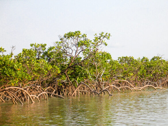
In many undisturbed tropical or subtropical regions there are natural landforms and vegetation that can help to reduce the impacts of storm surge and wave action. Mangroves, for example, that can live in salt water are recognized for their ability to trap sediments and stabilize shorelines. Mangrove forests can reduce risks from coastal hazards such as waves, storm surges and tsunamis. They have the ability to reduce both wave heights and flood depths and can lessen the damage landward of the forests. Mangroves grow occur worldwide in over 120 countries and territories, primarily between latitudes 25° north and 25° south, and most often along low-energy coastlines and within embayments and coastal lagoons. In the continental U.S., mangroves are limited to the Florida peninsula and a few areas along the coasts of Louisiana and south Texas. While not originally present in the Hawaiian Islands, they were introduced to stabilize mudflats on Molokai in 1902, and have subsequently invaded nearly all of the other islands. While mangroves are now understood to play an important role as a buffer to the impacts of tropical cyclones, it is estimated that about 35% of mangroves across the planet have now been removed or destroyed. Whether for shrimp or fish farming, wood products, or access to the shoreline for development, wholesale mangrove removal has devastated large areas of these unique trees, exposing the shoreline to the impacts of storm surges and waves. Recognizing the exposure when mangroves have been removed, reforestation is beginning in some areas to rebuild these natural barriers. Thailand, Indonesia and Florida are just a few areas where active mangrove restoration projects have been implemented.
Dunes also can provide a partial barrier to storm surge and wave attack, although being just piles of unconsolidated sand, their effectiveness is limited and they can be removed quickly under prolonged wave attack when sea levels are elevated. Coral reefs also provide a natural barrier in latitudes where reefs are healthy and continuous. In many locations, however, human activity or development has removed, altered or otherwise reduced the extent or effectiveness of these natural barriers and buffers. Whether mangroves, dunes, marshes, or coral reefs, natural protection takes no maintenance, has no costs, and can repair or regrow after major tropical cyclone or storm damage, thus helping buffer shorelines at far less cost than virtually any engineering solution.
Hurricane Warnings and Evacuation
Hurricanes, floods and other weather-related hazards should no longer come as complete surprises, at least in the U.S. We now have a robust system of orbiting satellites, specialized aircraft, and gaging stations for river levels and rainfall that allow us to detect, monitor and track severe weather systems before they reach coastlines or populated areas. In contrast to earthquakes, where prediction has eluded us to date, we do much better with atmospheric phenomena. There is always uncertainty involved, however, because tropical cyclones can change course, increase or decrease speed, and gather strength or lose energy along their tracks. Nonetheless, the U.S. National Hurricane Center attempts to provide 12-24 hour warnings of the probable paths of all tropical storms so that the precautions, evacuations, or other preparation can be initiated prior to landfall. This does require, however, that people listen to or have access to the warnings and respond appropriately. Last minute evacuations are risky when many residents or visitors are trying to get off of one of the barrier islands along the Gulf or Atlantic coast, because the islands may only be connected to the mainland by a narrow bridge or an occasional ferry. Some so called “hurricane parties”, where people who have never experienced an Intensity 4 or 5 hurricane believe that they are immune from hurricane danger and will be OK, end very badly when there is literally nothing left of the party house. Looking at areas that have been impacted directly by large hurricanes and observing the magnitude of the damage should provide enough information and perspective on the wisdom of taking all precautions and leaving a potential impact area well in advance of predicted landfall.
Construction Standards and Building Codes
There are no national building codes for dealing with hurricanes, so it falls to state or local government agencies to develop and then enforce their own standards and codes. With any large natural disaster accompanied by major property losses, there is often an immediate legislative reaction aimed at developing more stringent building standards. There is typically a narrow window, however, in which to accomplish these changes, and then another issue rises on the legislative priority list, and the disaster is soon a distant memory. When proposals are made to strengthen building codes, it may be years before they are approved or implemented, and there will nearly always be opposition from developers, speculators, or builders who aren’t worrying much about ever living in the structures they are building and selling. History has shown that where stringent standards have been adopted and enforced, damage can be held to a minimum under most storm conditions. Florida’s Coastal Construction Control Line is a good example. This Control Line delineates shoreline areas that are subject to 100-year storm impacts, whether erosion, flooding or other forces, and requires that any habitable structure meet certain construction standards. Experience has shown that homes can be significantly strengthened in order to better resist the impacts of hurricane forces at only modest increases in construction costs. None-the-less, when a shoreline community or typical home takes a direct hit from a Category 5 hurricane such as Ike, the probability of suffering major damage is still going to be very high. Very few typical wood frame or lightweight structures are a match for 180 mph winds and storm surges of 6 or 8 feet. Building or buying directly on the back beach or low frontal dunes carries some very real risks that need to be understood. The sand beneath your foundation was probably deposited there by waves or wind in the not too distant past, and the likelihood of waves and storm surge impacting the area in the future is very high, and increasing with each additional inch of sea-level rise.
She survived Hurricane Sandy. Then climate gentrification hit
Kimberly White Smalls needed her coastal home rebuilt, but like other Black residents of New York’s Far Rockaway neighborhood, she was moved instead…
Rebuild or Leave ‘Paradise’: Climate Change Dilemma Facing a Nicaraguan Coastal Town
Two major November hurricanes slammed into the same part of Nicaraguan coast, laying waste to the Miskito village of Haulover. Faced with a future of intensifying storms, the residents must now consider whether to abandon their way of life by the ocean and move inland.
Hurricane season: Record number of named Atlantic storms
This year’s Atlantic hurricane season has broken the record for the number of named storms, the US National Hurricane Center says.
Zeta leaves at least 6 dead and nearly 2 million without power
Zeta has killed at least six people after bringing high winds, heavy rain and up to 10 feet of storm surge in some areas. The storm struck southeastern Louisiana as a powerful Category 2 hurricane on Wednesday, leaving millions without power along the Gulf Coast.
NASA Confirms Development of Record-Breaking Tropical Storm Wilfred, Ending Hurricane List
The list of hurricane names is officially used up with the development of the 23rd tropical cyclone of the year. Tropical Storm Wilfred just formed in the Eastern Atlantic Ocean today,.
Five cyclones churn in Atlantic Ocean for only second time in history
For only the second time in recorded history, five tropical cyclones are churning in the Atlantic Ocean at the same time.
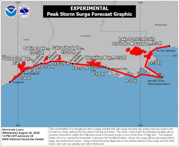
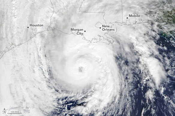
Why Hurricane Laura’s Storm Surge Could Be Unsurvivable
Having strengthened with astonishing speed into a Category 4 storm, Hurricane Laura will make landfall in Texas and Louisiana sometime early Thursday morning. With the landfall comes a dreaded storm surge—a rise in water level generated by a storm—that scientists say could spread seawater up to 30 miles inland, an inundation the National Hurricane Center just called “unsurvivable…”
Hurricane Laura tracks toward US Gulf Coast after slamming Haiti
Hurricane Laura is expected to intensify over the Gulf of Mexico and become a major hurricane prior to striking the upper Texas or southwest Louisiana coasts late Wednesday or early Thursday.
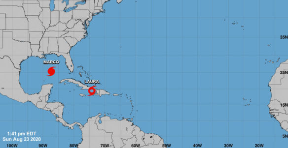
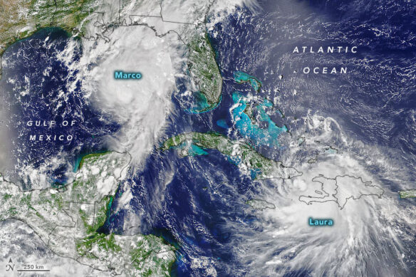
Marco becomes a hurricane as the Gulf Coast braces for 2 cyclones
The Gulf Coast will get walloped by a pair of hurricanes this week, bringing torrential rain, fierce winds and ferocious storm surges.
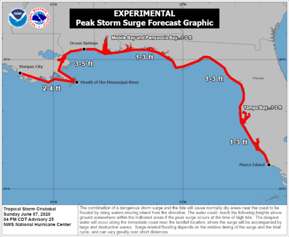
Tropical Storm Cristobal nears landfall in Louisiana with dangerous coastal and inland flooding
Tropical storm warnings stretched from the coast of central Louisiana to the western Florida Panhandle, while storm surge warnings covered the southeastern Louisiana coastline to near Biloxi. A 5-foot surge had already inundated some coastal areas in southeast Louisiana and Mississippi.
Mumbai bracing for the ‘first cyclone in years’
The heaving city of 20 million people, which is India’s financial and entertainment capital, has been spared of cyclones in modern history. Mumbai hasn’t “experienced a serious cyclone landfall since 1891”. All that could change on Wednesday when a severe cyclonic storm with wind speeds from 100 to 120 kmph (60 to 75 mph) could hit the city and India’s western coast.
Long-term data show hurricanes are getting stronger
In almost every region of the world where hurricanes form, their maximum sustained winds are getting stronger. That is according to a new study involving an analysis of nearly 40 years of hurricane satellite imagery.
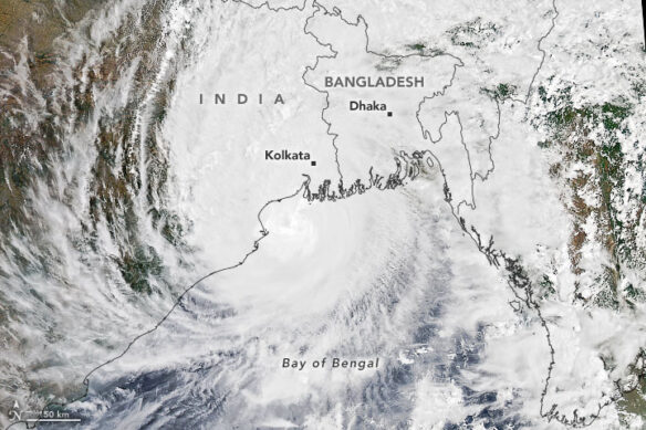
Cyclone Amphan Reinforces Urgent Need for Climate Adaptation Planning
The south of Bengal has been decimated by the category 5 super cyclone Amphan during the night of 20 May and the early hours of 21 May. However, when combined with other threats, most of which have an anthropogenic origin, the sustenance of the ecosystem can indeed be found wanting.
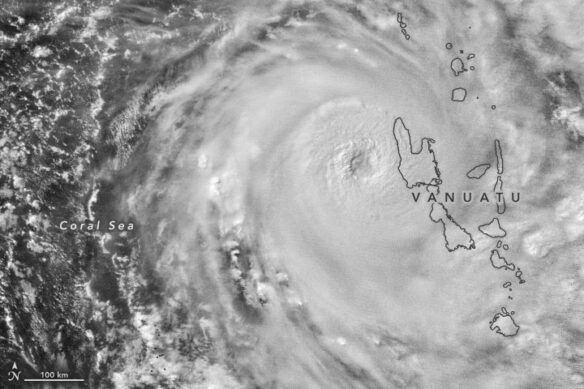
Category 5 tropical cyclone wreaked havoc on Vanuatu
Tropical Cyclone Harold made landfall on the Pacific island nation. By midday, Harold was a category 5 storm with sustained winds of approximately 215 kilometers (135 miles) per hour near its center, making it one of the strongest storms ever to hit the nation.
Twin bomb cyclones to merge into one of strongest-ever storms in North Atlantic
A potentially unprecedented scenario is unfolding in the North Atlantic on Friday, as a bomb cyclone batters Iceland with hurricane-force winds and blizzard conditions, just as another bomb cyclone, known as Storm Dennis, rapidly intensifies behind it.
A storm brought some of the largest waves ever recorded off the California coast last week. One was 75-feet tall
The bomb cyclone that pounded the West Coast last week brought with it some of the tallest waves ever recorded off the California coast. A monstrous 75-foot wave was recorded about 20 miles off the coast of Cape Mendocino in northern California.
Freak storms of 2019 Atlantic hurricane season left trail of destruction and revealed climate change fingerprints
Dorian and Lorenzo, wbrought the count of Category 5s in the Atlantic since 2016 up to six, and marked the fourth year in a row with at least one Category 5, the longest stretch on record. The historic intensity of both Dorian and Lorenzo, exhibited influences consistent with warming ocean waters and climate change.
Survivors’ tales part of the art in Superstorm Sandy exhibit
The stories of people who survived Superstorm Sandy, scrawled in their own handwriting, are an integral part of a new art exhibit remembering the deadly storm and the devastation it caused seven years ago. The “Just Beachy After Sandy” exhibit at Monmouth University in New Jersey is on display through early December.
Ferocious typhoon leaves as many as 33 dead, floods over 1,000 homes in Japan
Typhoon Hagibis made landfall south of Tokyo on Saturday evening and battered central and northern Japan.
Hurricane Nicole sheds light on how storms impact deep ocean
Hurricanes can cause significant damage to human structures on land, and often permanently alter terrestrial landscapes. But these powerful storms also affect the ocean.
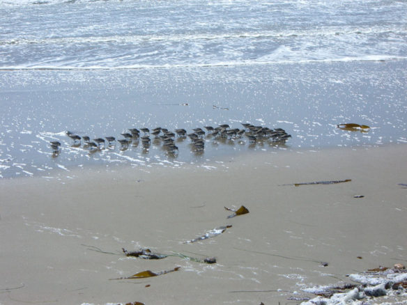
Coastal birds can weather the storm, but not the sea
How can birds that weigh less than a AA battery survive the immense power of Atlantic hurricanes?
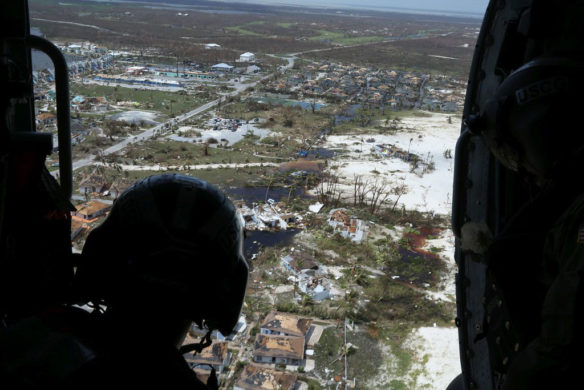
Major Oil Spill on Grand Bahama Reaches the Ocean, Damages Coastline
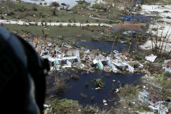
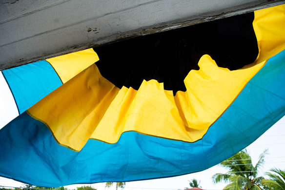
An oil spill caused by Cat 5 Hurricane Dorian has been spotted in the ocean and has damaged the Bahamas coastline, the Norwegian energy company that owns the oil storage facility, Equinor, confirmed on Wednesday, a week and a half after the hurricane blew the lids off of six massive crude oil tanks.
Thousands of Dorian survivors desperate to evacuate wrecked Bahamas as death toll climbs to 44
There are about 76,000 people left homeless and in need of assistance in the Abaco Islands and Grand Bahama Island, the U.N. said.
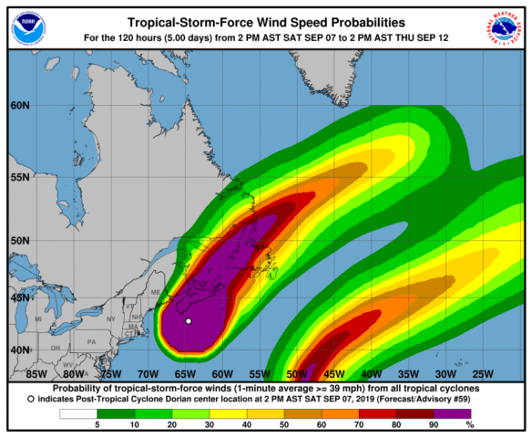
Hurricane Dorian gains strength again as it heads toward Canada
Hurricane Dorian strengthened to a Category 2 hurricane Saturday afternoon as it began moving past the coast of Maine towards the east coast of Canada with maximum sustained wind speeds of 100 mph.
Hundreds stranded on Outer Banks island, ‘catastrophic’ flooding as Hurricane Dorian moves off coast
“We went from almost no water to 4 to 6 feet in a matter of minutes,” said Steve Harris, who lives on Ocracoke Island, North Carolina.
Hurricane Dorian: ‘We’re at the frontline of climate change but we don’t cause it’, says Barbados PM – as it happened
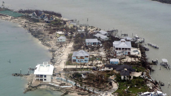
The “force and size” of Dorian took everyone by surprise, a situation made worse by the hurricane stalling over the archipelago. “Grand Bahama is not in good shape at all because 70% of it was under water,” St George said.
Dorian obliterated the Bahamas. The US must help
The destruction is near-total in some places. Early aerial photos show whole towns inundated, shipping containers tossed around, roofs floating on stagnant floodwaters, airports submerged. Dorian left a massive swath of Grand Bahama Island underwater.
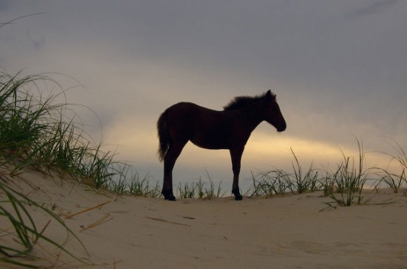
The wild horses of the Outer Banks won’t evacuate. They have a special trick to survive hurricanes
A bunch of majestic horses that spend their days frolicking on the beach in North Carolina’s Outer Banks will not be evacuated. They will move to higher ground and gather under sturdy oak trees to shelter.