Kara Sea
Excerpts from Rachel Krech and Jessica Bachman, Reuters
Russia and BP finally reached an agreement over plans to drill in the Arctic Circle back on Feb. 15. BP became a major player after it turned its attention elsewhere after hitting numerous offshore drilling roadblocks in the U.S. following the Gulf of Mexico oil spill.
The drilling is set to take place in the Kara Sea, which the Russian government asserts is a barren wasteland and dead zone that was originally used as a dumping ground for the country’s nuclear waste.

Nuclear Dumping Grounds, Kara Sea
Russia is the world’s top oil producer and the industry plays a huge role in the country as the federal budget receives more than half of its annual revenues, or 4 trillion roubles ($136.8 billion), from oil and gas projects.
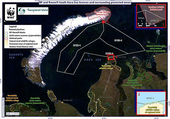
But the World Wildlife Fund (WWF) said the locations of the three drilling blocks in the Kara Sea are encroaching on areas that are a part of a protected Russian national park that sees large numbers of vulnerable and endangered species, including polar bears and several different kinds of whales.
The Russian government is arguing against the WWF’s claims, stating that boundaries of the Russian Arctic national park haven’t been drawn yet, but the Russian branch of WWF is reminding them that the lines were clearly drawn when the park was created last year with specific coordinates and that the drilling blocks are undoubtedly encroaching on the boundaries.
The WWF has had numerous conflicts with the Ministry of Natural Resources and claims that the ministry often awards oil and natural gas licenses without taking any aspect of environmental health and protection into account.
Russia is currently world’s top oil producing country, surpassing the U.S. and all Middle East countries, and has tapped its oil reserves in Western Siberia since the 1970s. Russia’s oil industry plays a huge role in the country as the federal budget receives more than half of its annual revenues, or 4 trillion roubles ($136.8 billion), from oil and gas projects.
But the government has expressed its concern numerous times regarding the drastic decline of Siberian petroleum reserves, emphasizing the importance of turning their attention to offshore drilling in the Arctic Circle.

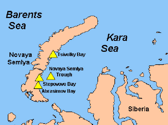
The Kara Sea is part of the Arctic Ocean north of Siberia. It is separated from the Barents Sea to the west by the Kara Strait and Novaya Zemlya, and the Laptev Sea to the east by the Severnaya Zemlya. Image Source: WWF
Oil drilling licenses have been distributed for drilling operations in the Kara Sea, off the coast of the Novaya Zemlya archipelago, which borders the sea along the west and up to the north.
The archipelago was originally used as a nuclear testing site during the Cold War and the most powerful nuclear bomb ever detonated was tested on the island in 1961. It is now home 2,700 people in the southwest portion and the Russkaya Arktika National Park is located the northern most tip, which covers about 10 percent or 9,000 square kilometers of the land and an additional 5,000 square kilometers of surrounding coastal water.
The WWF says the oiling drilling licenses cut off about 45 square kilometers of water that was designated as protected area and that the government is attempting to redefine the boundaries to suit their oil drilling interests. The Russkaya Arktika National Park was created back on June 15, 2010, but licenses for the Kara Sea were granted to Rosneft, an integrated oil company mostly owned by the Russian government, only four months later.
Alexander Mednikov, a lawyer with the Russian maritime law firm Jurinflot, said it is not uncommon in Russia for government agencies to come up with different calculations of territorial water boundaries. This was especially the case in remote places like the Arctic, where there was little history of government and private sector activity.
“In the absence of clear regulation, each agency could be right in their own way on where the territorial waters end and the exclusive economic zone begins,” Mednikov said. “They may not have consulted each other on their methodology for calculating the borders.”
“Russia has an enormous coastline, and in the Arctic there are many places where the territorial waters have still not been measured because there hasn’t been a need for that. Now, with commercial activity up there, this can become a gray area,” said Mednikov.


