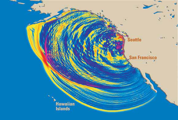
In this computer simulation, tsunami waves are radiating outward after a magnitude (M) 9 earthquake that occurred on the Cascadia Subduction Zone offshore of northern California, Oregon, and Washington on January 26, 1700. This view shows the waves 4 hours after the quake. Colors indicate wave heights—red is highest. Along parts of the coast of the Pacific Northwest, 30-foot-high (9 m) waves rushed inland. Within 20 hours the tsunami did damage throughout the Pacific, and it is well documented in written records from Japan. For more information: Orphan tsunami. Captions and Image source: USGS
Excerpts;
About 5,500 more people could survive a major tsunami hitting the Pacific Northwest if they just walk a little faster to higher ground after roads are knocked out, a new study shows…
Read Full Article, Times Standard / AP (04-13-2015)
Original Study: “Community clusters of tsunami vulnerability in the US Pacific Northwest,” PNAS
Rising Above the Risk: America’s First Tsunami Refuge, Science Daily (10-21-2014)
Washington’s coast is so close to the seismically active Cascadia Subduction Zone that if a megathrust earthquake were to occur, a tsunami would hit the Washington shoreline in just 25 minutes. One coastal community is preparing for such a disaster by starting construction on the nation’s first tsunami evacuation refuge…


