Skip to content
  • Home | News
  • Coastal Issues
    • Sand Mining
    • Pollution
      • Plastic
      • Hydrocarbons
    • Shoreline Armoring + Coastal Engineering
    • Dams + Sand Supply Reduction
    • Beach Nourishment + Maintenance
    • Problematic Coastal Development
    • Habitat | Ecosystem Destruction
    • Climate Change | Sea Level Rise
  • Beach Basics
    • Reading a Beach
    • Waves
    • Exploring Beach Sand
    • Tides
    • Cyclones | Typhoons | Hurricanes
    • Sand Dunes
    • Coral Reefs
    • Seashells
  • Coastal Care JR
  • Art + Science
  • Resources
    • Book Reviews
    • Beach Science Bibliography
  • Ask an Expert
  • About
  • Contact

Day: December 2, 2012

Lidar Confirms Sandy’s Dramatic Coastal Change Impacts and Future Coastal Vulnerability

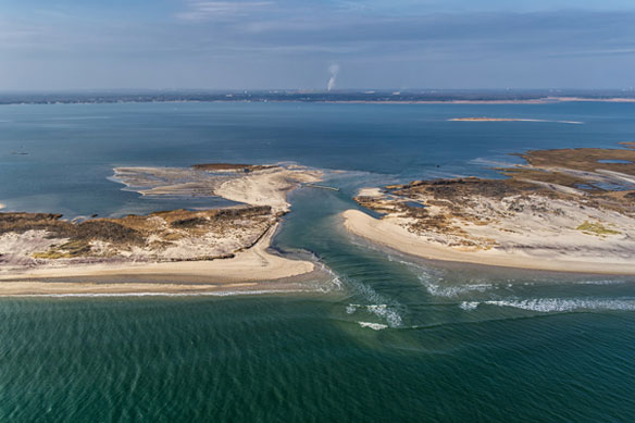
The extent of Hurricane Sandy’s wrath, and the future coastal vulnerability of the region, is clear in a new U.S. Geological Survey analysis of recently collected lidar coastal data. The research documented particularly dramatic impacts within the Fire Island National Seashore on Long Island, NY.

Menu
  • Home | News
  • FAQ
  • Privacy Policy
  • Legal Notice
  • Archived Menu
  • Contact
Instagram Facebook Twitter

© 2010 – 2022 CoastalCare.org