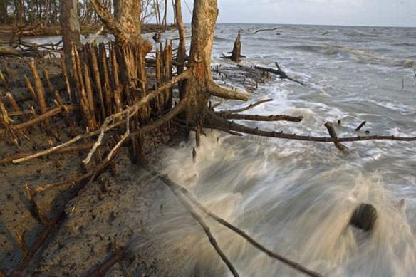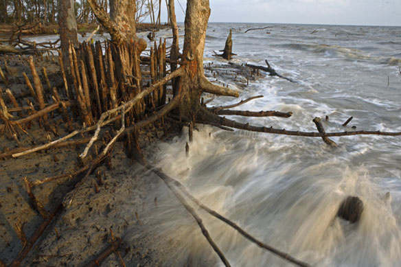
Bangladesh Coastal Erosion. Photo Source: Laman/National Geographic Image Collection
Excerpt from The Financial Express, Dredging Today
Bangladesh’s coastal area covers about 20% of the country and over thirty percent of the net cultivable area. It extends inside up to 150 km from the coast. Out of 2.85 million hectares of the coastal and offshore areas about 0.83 millions hectares are arable lands, which cover over 30% of the total cultivable lands of Bangladesh. A part of the coastal area, the Sundarbans, is a reserve natural mangrove forest covering about 4,500 km2. The remaining part of the coastal area is used in agriculture. The cultivable areas in coastal districts are affected with varying degrees of soil salinity. The coastal and offshore area of Bangladesh includes tidal, estuaries and river floodplains in the south along the Bay of Bengal.
Barisal division, Khulna division, and some districtsin the Patuakhali and Noakhali areas, form the southern region of Bangladesh. The greater part of this region that roughly is equally to one fourth of the country spatially, is coastal in nature or relatively closer to the sea than other regions. It shares common economic prospects and challenges. The vast region is expected to be affected by the worldwide climate change. The southern region of Bangladesh is already undergoing the adverse effects of interventions in the free-flow of waters.
Structures built on the other side across the border have adversely affected the free flow of river waters into lower riparian Bangladesh. Already, there is an alarming fall in such flows, impacting very unfavourably the environment, ecology, habitat and people’s livelihood, particularly in the district of Khulna. The saline sea waters have been pushing up inland because of the poor flow in the rivers that cannot adequately flush out the sea waters. Big areas near the coasts have been affected by salinity and progressively more and more areas are meeting a similar fate.
Not only salinity, the leaner flow in the rivers of the southern region has also meant faster deposition of silt and the raising of their beds. Thus, the rivers across the region needs comprehensive dredging. Two consequences can be expected from such dredging. The flows in them could improve having a better effect in reducing salinity. Flood protection to some extent may also be achieved from the same. Government in Bangladesh appears to have firmed up a plan to engage in thorough river dredging in this area.
Salinity is not only threatening agriculture in the area, it is also posing as a serious threat to various flora and fauna in the Sunderbans forest which Bangladesh is otherwise proud of, as one of its great possessions.
Salinity has been such a problem for the region that in large tracts of what had been once cultivable lands, nothing of much value grows nowadays. People on a large scale were pushed to the brink and migrated to other areas of the country. The saline taste of even the underground tubewell water is a risk to public health. Thus, apart from river dredging, it should be planned whether fresh water from other areas of the country can be diverted to this region. Preservation and use of rain water need to be promoted here. Success was achieved in recent years in developing new and study varieties of rice plants that can grow well even under saline conditions. These varieties of rice and their cultivation will have to be popularized in this region. Storms and surges from the sea also pose big threats. Clearly, any overall plan for the development of the southern region, must incorporate the building of coastal embankments, sea walls, etc., both to hedge people against storms like the devastating storm, Alia and also from the looming threat of sea-level rise. Bangladesh is expected to be a major recipient of funds from donors to protect itself from climate change. A big part of such funds should be spent in the southern area considering its special vulnerabilities.
In this context, Prime Minister Sheikh Hasina spoke about an integrated plan for the development of the southern region. For any plan for development of the southern region cannot be isolated in its parts. All segments under a comprehensive plan must be simultaneously attempted or integrated to get the best results. All concerned would now expect the government to firm up actions for such an area-focused comprehensive plan of action in an integrated way in order to help reverse the present situation in the region of the country and to provide a strong base for its steady and sustained growth.
Salinity Problems In Coastal Regions of Bangladesh
Finding Sustainable Ways to Cope With Sea Level Rise, in Coastal Care


